来源:海洋灾害重点实验室 编辑:周姣娣 作者:蒙柳清
近期,我实验室田义超副教授团队在亚热带茅岭江河口典型入侵红树林地上生物量及其分布格局研究方面发表论文“Aboveground biomass of typical invasive mangroves and its distribution patterns using UAV-LiDAR data in a subtropical estuary: Maoling River estuary, Guangxi, China”在国际知名期刊Ecological Indicators(中国科学院二区TOP,影响因子4.559)在线发表。该论文第一完成单位为北部湾大学,第一作者为田义超副教授,通讯作者为黄鹄教授。据悉,这篇论文是田义超副教授2021年在无瓣海桑生物量反演方面的工作延续,论文的题目为“Aboveground mangrove biomass estimation in Beibu Gulf using machine learning and UAV remote sensing”,该论文于2021年发表在国际知名期刊Science of the Total Environment(中国科学院一区TOP,影响因子7.963)。
康熙岭红树林自然保护区作为北部湾最北端的红树林分布区,是中国典型的南亚热带河口、港湾和海岸滩涂湿地复合型生态系统保护区。该区域的红树林是外来红树植物无瓣海桑的种植区,近年来入海口团和岛海岸滩涂内的无瓣海桑出现了大面积的天然扩散,对当地的桐花树树种的生长空间产生了一定的影响。但是,目前关于扩散区域无瓣海桑生物量估算方面的研究还是及其罕见和匮乏的,尽管无人机激光雷达在红树林垂直三维结构调查方面具有一定的优势,但是该区域已有红树林调查成果多以样地调查方法为主,很少有学者将样地实测数据和激光LiDAR数据相结合,并采用机器学习方法估算入侵无瓣海桑树种的地上生物量。这两篇论文中的红树林结构参数提取方法均采用了我们团队自主研发的激光雷达生物量反演LiMARS系统,研究结果论证了无人机激光遥感和机器学习算法在入侵红树林物种生物量估算上具备可行性,可为入侵红树林生态系统的评估与当地红树林树种的保护提供科学依据和技术支撑。

图1. Invasive mangrove diffusion process (A), Sonneratia apetala community (①②), Mangrove
tidal channels crossing process (③), Measurement of 1.3 m-diameter Sonneratia apetala (④⑤⑥).

图2. UAV system composition (a), UAV takeoff position(b), RTK positioning equipment (c),
Commissioning of UAV equipment and laser point cloud carrying process (d), and Initial stage of UAV takeoff (e).

图3. Lidar mangrove aboveground biomass retrive system(a), Lidar processing toolboxs(b), Mangrove height variables extraction modules (c), and Mangrove intensity variables extraction modules(d), Digital elevation model generation modules(e), Digital surface model generation generation modules(f) and Canopy height model generation modules(g)
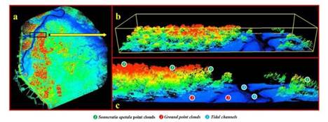
图4 Laser point cloud acquired by UAV (a), local magnification of laser point cloud profile (b), and three different laser point cloud details display information,namely, Sonneratia apetala point clouds, Ground point clouds and Tidal channels point clouds (c).
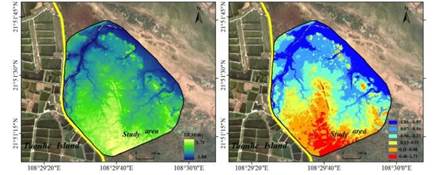
图5 Spatial distribution of DEM, and its hierarchical spatial distribution calculated.
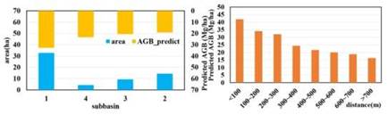
图6 Histogram of predicted biomass of mangrove in subbasin, and spatial distribution of AGB of mangroves at different distances from tidal channels.
本研究由国家自然科学基金资助项目(No. 42061020);广西壮族自治区自然科学基金资助项目(No. 2018JJA150135);国家自然科学重点基金资助项目(No. 41930537);广西科技重大专项资助项目(No. AA18118038);北部湾大学高层次人才引进项目(批准号:2019KYQD28)共同资助完成。
图7 Ecological Indicators研究论文成果首页
文章详细信息:
Yichao Tian , Qiang Zhang, Hu Huang* , Youju Huang, Jin Tao, Guoqing Zhou,Yali Zhang , Yongwei Yang, Junliang Lin;Aboveground biomass of typical invasive mangroves and its distribution patterns using UAV-LiDAR data in a subtropical estuary: Maoling River estuary, Guangxi, China,Ecological Indicators,2022,136:108694.
文章链接:https://doi.org/10.1016/j.ecolind.2022.108694
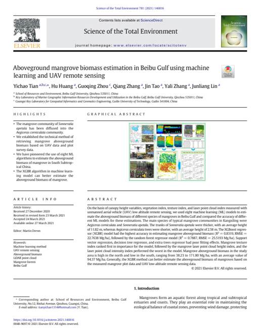
图8 Science of the Total Environment研究论文成果首页
文章详细信息:
Yichao Tian , Hu Huang, Guoqing Zhou, Qiang Zhang, Jin Tao, Yali Zhang, Yongwei Yang, Junliang Lin;Aboveground mangrove biomass estimation in Beibu Gulf using machine learning and UAV remote sensing,Science of the Total Environment,2021,781:146816.
文章链接:https://doi.org/10.1016/j.scitotenv.2021.146816


 科研项目
科研项目